
Do you recognise the buildings in the photograph below? What is there now?
The photograph is part of the Aerofilms collection now held by English Heritage. Aerofilms, founded in 1919 by two World War I veterans, F.L. Wills and C. Grahame-White, took aerial photographs of towns and villages all over the British Isles.
The collection of photograph albums and negatives is now held by English Heritage, who are hoping to set up a project to catalogue these photographs in detail.
Your help is needed! If you recognise the landmarks in this photograph, please use the Add a comment link at the foot of this page.


Add your comment about this page
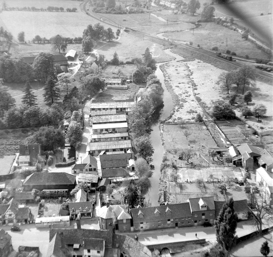
This is such a useful photograph for researching the history of the High Street. What particularly interests me is the old Tithe Barn that was owned by the Rector, sitting behind what was recently the Brewhouse Gallery in the High Street. (Sadly the barn was demolished to create a better access route into Helmets) Behind the Tithe Barn is the Crinkle Crankle walled garden and within, the 15thC Old Rectory with moat in front. Beyond all this lies Rectory Meadow which was all Glebe land owned by the Rector, and then led down to what remained of Bury Farm. Still remaining are the 15thC Bury Farm Cottages, which were originally “Hall Chambers & Gatehouse” to the moated Wheathampsteadbury Manor.
The butcher’s shop was still in use in 1984 – Simons. The three large trees in the middle of the field in the upper right of the photo were also there then. They were in the middle of the green for Kingfisher Close. The tallest has since been felled, having succumbed to disease.
Ruth mentions the cultivated land behind the mill, this is the garden of Leabank, this is immediately post war and food was rationed so people grew as much as possible, the buildings behind the house on the right of the picture were related to our family butchers shop, the taller one face onto the drive was the laundry, I can remember keeping my pet rabbits in there. It also looks as if the garden and field behind could be flooded. The further land is part of my great grandparents home, later developed into test beds for Murphy chemicals, the old mags pond area is just about visible by the trees in front of the railway.
You can see the Helmets light industrial site well in this photo extending behind what is now the Brewhouse gallery. Also Bury Farm going down to the river and what migh be the old Fernery – part of the rectory glebe land. Interesting to see how well cultivatred land was behind the mill – where there has been a mill since Domesday!
Wheathampstead High street is at the bottom of the picture. You can see the bridge over the River Lea, opposite which is the old Mill building with the windows with the pointed roofs. On the left of the picture is a tudor looking building which has recently been a cafe but is now empty. Between this and the building on the right hand side is now a small road leading to a new housing estate where in this picture are a number of outbuildings.