Ashwell. Parish
Colin Wilson


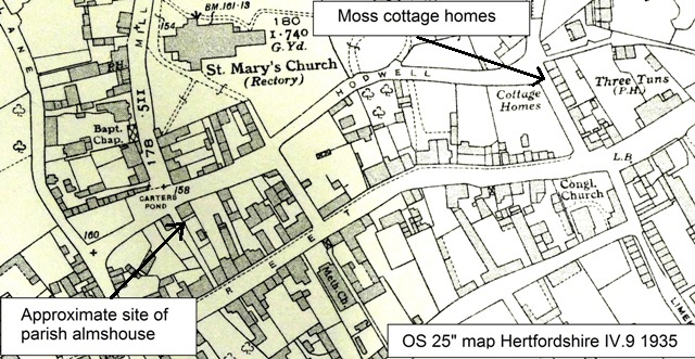
Alms Lane in Ashwell was not always known by that name; an 1877 map shows it was formerly Pickings Lane. The implication is there was a reason for a name change. While the exact location of the almshouses is not certain, they may have been opposite what is now the museum (formerly the old Town House).
The 1829 rate survey for Ashwell shows the parish were proprietors of property 126. The Ashwell tithe map for 1841 shows 3 properties in Alms Lane owned by the parish authorities at lots 360, 361 and 362. It may be of use to compare the 1898 and 1940 OS 25” maps to compare which buildings existed, although they are not annotated. Consisting of a dwelling house and 10 cottages, they were pulled down in the 1930s when the telephone exchange was built. There is the chance they existed for nearly 300 years with hardly any mention in the public record.
The overseers’ accounts for 1676/7 note that money was spent on the almshouses. Before 1834, the overseers’ accounts and other documents show the parish owned some almshouses, possibly in Alms Lane.
One interesting anecdote concerns Elizabeth Gordge. She was widowed at the age of 25. Her stepchildren found apprenticeships, and she lived in the almshouses till her death at the aged 46. Most almshouses cater for elderly people, so the fact that she was helped at such a young age is unusual.
Unfortunately at the time of writing it was not possible to consult all the relevant maps due to Covid restrictions; most of the information above was gleaned from David Short’s article. A previous visit to the Ashwell museum produced no further information.
Location
Georef: 526704 239669 approx
Grid ref: 2o 02′ 26″N 0o 09′ 22″ W approx
OS 25” map Hertfordshire IV.9 rev 1897, pub 1898 and rev 1937, pub 1940
OS 25” map Cambridgeshire LVII.14 surveyed 1877, pub 1888 shows Alms Lane was formerly Pickings Lane
References
There do not appear to be any references in Clutterbuck, Cussans or Victoria County History. However, these publications tend to record benefactions by individuals rather than parish facilities.
Hertfordshire – a Caring County? Ed Stephen King and Gillian Gear
Pages 129-30 and 144-5 Article by David Short ‘Pensions for the Care of the Elderly in Ashwell 1670 – 1770
Pub Hertfordshire University Press 2013 ISBN 978-1-909291-12-6
Ashwell tithe map. Copy held at HALS ref DSA4/6/2


Add your comment about this page